Flight Wisp1c_5
Preparation
My wife assisted, and we tried braiding two strings with one strand of 36ga magnet wire for the antenna and counterpoise this time. It came out at the same weight (1.8g) as a single strand with the wire, and a ton of nail polish.

This time, Following Dave/VE3KCL's advice, I ran a little tape up onto the two balloons as I joined them. There is less stretch near the edges than there is in the center, so hopefully this won't be a problem. I also ran a strand of backup tether between the two balloons, just in case the tape lets go.

Here's how the two-balloon configuration looked, just prior to launch.

Testing the tracker, just prior to launch.

Specifications
Tracker: wisp1c_5
Bands: Alternating 20m / 30m WSPR, gatewayed to APRS: KD2EAT-15
Power: Solar only
Weight: 14.5g
Free lift: 5g
Launch
There was a touch more breeze than the launch for wisp1c_4, but not bad. This puff relaxed, and the balloon went more upward. I ended up letting it go over the ledge to my right. The tracker briefly went below roof level, and then climbed away. Roof launches make life SO much easier!


Day 1
The initial climb to float altitude worked beautifully. We achieved float within a few kilometers of predicted.
Mark Conner / N9XTN shared the Ensemble model for the flight. Its colorful tendrils look pretty good!

End of Day 1
Day 1 ended on a sour note. After passing over the Boston area, it appears that propagation really went to hell. We hadn't heard much on 30m through the eastern half of Massachusetts. It went completely silent, and then we lost 20m. As a result, we had little telemetry in the final hours of daylight.
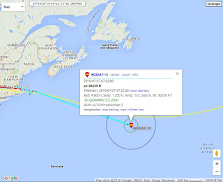
The final full packets were received here, off the coast of main. Things looked solid with the altitude at just over 30,000 feet and the supercap and solar doing well. We were in grid square FN51wt. Then it went silent.

We did receive a few spurious telemetry packets. This last one was received at 6:22pm EDT:
2016-07-06 22:22 | QO6LO | 10.140148 | FN61 | +43 | K9AN | 30
We were in grid square FN61lo, 93km further East on a heading of 104 degrees.
Presuming the final altitude didn't change by 1000 meters or more, the final telemetry was:
| CallSign | KD2EAT |
| GridSquare | FN61LO |
| Flight ID | 16 |
| Altitude | 9222 |
| GPS LOCK | Y |
| Sats | 6 |
| Solar V | 1.00 |
| Batt V | 4.60 |
| OAT | 5.0 |
That's quite consistent with the data we were receiving throughout the late afternoon.
We'll hold tight and hope it wakes up in the morning to better band conditions!


Day 2
It's alive!

As the afternoon wore on, the band conditions improved a little, and we received more packets. 30m was still dead, but 20m was improving. In mid-afternoon, we approached this storm, which has some pretty high clouds. Crossing our fingers! That green color indicates clouds at nearly 40,000 feet, well above our cruising altitude.

Propagation improved on 20m near the end of the day. The balloon looked strong and stable at the end.

At the current pace, I imagine the balloon will wake up at The Azores! It's definitely moving slower than the last balloon.
Statistics on GPS performance are below. I would venture to say that >something< is wrong with this GPS. I need to do more ground testing to validate that it's not a software problem.
Day 3
We ended Day 2 at grid GM86ep and awoke on Day3 at HM26ou. We covered a distance of 755 kilometers overnight. We ended the day at HM58si, for a distance traveled by day of 583 kilometers. So, over about 24 hours we covered 1338 kilometers (55.75 kph, or 34.6 mph).Here's the initial start, with the prediction from Day 3.

Here we are at the end of the day, with a revised prediction.

Thankfully, it looks like we edged past that front of weather without difficulty.

Though the bands were bad again, we got enough telemetry to see that the envelopes are continuing to stretch. We were at 9333 meters for most of the day, with a few packets at 9444. I expect we'll have quite a few at 9444 tomorrow.
The weather ahead still looks clear. Barring any unforeseen disasters, we should be back on the air tomorrow with the sun. Sunrise in the Azores is at 6:29 GMT (2:29 EDT). It generally takes about 90 minutes for the sun to rise high enough for the packets to flow. I'd expect the first packets around 4:00am, EDT.
Mark Conner / N9XTN ran a prediction this afternoon. Let's hope we don't follow the green!

Day 4
Day 4 started out well, with pretty good reception on the bands, and wind velocities increasing.

The day ended over the Bay of Biscay. We didn't follow the prediction very well, but at least we're moving faster!

The weather looks good going into the night cycle. I expect it'll be near Paris in the morning. Sunrise is at 6:30 Paris time, 12:30am EDT. It takes about 90 minutes for the sun to rise high enough to come online, so I'd expect packets around 2:00am. (Note: It ended up being 1:53am.)

Bogus Altitudes
I noticed a bogus altitude on APRS, and found it in the data coming into my "aprs2wspr" script today. The "thousands of meters" field is stored in the DBM value in the first of the two telemetry packets.Jul 09 10:39:06 [INFO] 2016-07-09 14:36 KD2EAT 14.097059 IN33 +50 DF2JP 20m
Note the "+50" DBM value. They're normally "+30". This had happened a few times in flight. I wasn't sure if this was an artifact of the tracker sending bad data, or whether the receiving station copied the data badly. Unfortunately, in the instances that I researched, only ONE station had received the packet, so I couldn't tell. Today, however, with band conditions improved, I was able to confirm that the tracker is sending the incorrect data.
| 2016-07-09 14:36 | KD2EAT | 14.097056 | -22 | 0 | IN33 | 100 | PI4THT | JO32kf | 1767 | 50 |
| 2016-07-09 14:36 | KD2EAT | 14.097073 | -26 | 0 | IN33 | 100 | PD0DH | JO21fv | 1603 | 48 |
| 2016-07-09 14:36 | KD2EAT | 14.097059 | -18 | 0 | IN33 | 100 | DF2JP | JO31hh | 1710 | 53 |
| 2016-07-09 14:24 | KD2EAT | 14.097013 | -26 | 1 | IN33 | 1 | DF1RN | JO30br | 1653 | 54 |
| 2016-07-09 14:24 | KD2EAT | 14.097057 | -17 | 0 | IN33 | 1 | F5OIH | JN06ci | 1090 | 68 |
| 2016-07-09 14:24 | KD2EAT | 14.097058 | -27 | 0 | IN33 | 1 | F5LHF | JN25em | 1397 | 75 |
Note that the previous packets showed "1 watt" (30 dbm) of output power, but this one showed "100 watts" (50 dbm) at all receiving stations.
So, the tracker is definitely sending bogus data. The next question is whether it's the GPS providing the bogus data, or something with my code. This will take a bit more research.
Day 5
We woke up on schedule at 1:53am. We were received well on both bands and moved at about 40mph throughout the day.

We covered great ground, and ended the day with one toe into the Czech Republic. Speeds were good all day, and GPS and radio performance were awesome. Still, there was one very obvious watchdog reset in the data.

Day 6
Day 6 started out right on time. The first beacon arrived about 12:04am EDT. Today was exceptional for two reasons. First, we passed through our first Geofenced area - Romania. As can be seen on the map below, we didn't beacon at all while inside the borders. It worked perfectly! Woo hoo! We got VERY lucky, as it was growing dark as we left Romania. The tracker literally uttered two packets and shut down for the day. Given the proximity to sundown, I was shocked it even beaconed.

The second exceptional thing about the day was the performance of the GPS and reception. The GPS never failed to get a lock on time, as shown by the reception data. Also, We had 100% reception of packets on 20m while we were beaconing. 30m wasn't bad either, at about 61% reception.

Day 7
We woke up as expected in the Black Sea, and executed a Loop-de-loop. The tracker had major problems today with late GPS locks, GPS resets and at least one watchdog reset. In Wisp2, I'm going to wire in a RESET line for the GPS and zap it if we have this kind of locking trouble to see if that improves matters. Even the soft resets didn't seem to last for long.

The weather as we come toward wakeup time looks pretty grim. Also, the balloon was headed back to Romania for a while, which means it will be geofenced as it hits this weather. It's going to be another nail-biter.

Day 8
We came through the weather just fine, and managed to clear Romania in plenty of time to beacon this afternoon. I ran a new prediction which is in yellow.

I also ran a hysplit with predictions for the next few days.

The GPS seemed to work VERY well today, and as usual, 30m was a pretty worthless band to transmit on.
Steady on!

The GPS seemed to work VERY well today, and as usual, 30m was a pretty worthless band to transmit on.
Steady on!
Day 9
We awoke on schedule on Day 9 and had an unremarkable day moving into Russia. The altitudes crept up a little near the end to 9666 meters. The GPS had a few glitches today, but it appears that the software resets were sufficient to bring it into line. The 30m band continues to disappoint.

Day 10
We are doing a walking tour of Russia, it seems. For much of the day, the tracker was traveling under 20 kph. The GPS was pretty stable, but we heard nothing on 30m all day.

Day 11
We awoke with the sun and beaconed once, and then weren't heard for a bit. Altitude looked great, at 9555 meters. Moving slowly. Finally hit Kazakhstan today!
Day 12
Speed has picked up. We averaged about 60 mph through the day, though the day, though propagation was lousy, so we didn't get a lot of data. We seemed to go straight down the middle of the Caspian sea.

Day 13
Our rugged little tracker is getting FAR away from any stations to receive it. We got a total of ONE packet last night. It was the second telemetry packet, and not the first packet. Due to a vaguery of the way the scripts are written, that means it didn't update the map. I just drew in where the single data point was located, along with a conjecture of the route in purple. The altitude was down to 9222 meters, but it's still serviceable. Let's hope for better reception tonight!
Day 14
No packets on day 14. It's possible that it's just not close enough to anyone to be heard. The bands have been bad for the last few days. Below is a map showing the one and only site that heard the telemetry packet the other day.

Day 15
No packets heard at 4+ hours into daylight where the tracker would likely be. I'll keep an eye out for a few more days. Prepping for another launch this coming weekend.
Daily Statistics
| Day | Band | Received Packets | Lost Packets | Percent Received | GPS Locks Missed | Probable GPS Resets | Probable Watchdog Resets |
|---|---|---|---|---|---|---|---|
1
|
20
|
89
|
15
|
85.6
|
7
|
1
|
1
|
1
|
30
|
52
|
52
|
50.0
| |||
2
|
20
|
50
|
58
|
46.3
|
16
|
4
|
1
|
2
|
30
|
4
|
102
|
3.8
| |||
3
|
20
|
49
|
69
|
41.5
|
15
|
5
|
1
|
3
|
30
|
0
|
118
|
0
| |||
4
|
20
|
71
|
23
|
75.5
|
25
|
13
|
1
|
4
|
30
|
11
|
79
|
12.2
| |||
5
|
20
| 124 | 4 | 96.9 | 3 | 0 | 1 |
5
|
30
| 77 | 45 | 63.1 | |||
6
|
20
| 84 | 0 | 100 | 0 | 0 | 0 |
6
|
30
| 49 | 31 | 61.2 | |||
7
|
20
| 76 | 18 | 80.9 | 36 | 26 | 1 |
7
|
30
| 41 | 49 | 45.6 | |||
8
|
20
| 63 | 7 | 90.0 | 2 | 0 | 0 |
8
|
30
| 5 | 59 | 7.8 | |||
9
|
20
| 115 | 15 | 88.5 | 5 | 2 | 0 |
9
|
30
| 12 | 114 | 9.5 | |||
10
|
20
| 80 | 120 | 66.7 | 4 | 1 | 0 |
10
|
30
| 0 | 120 | 0 | |||
11
|
20
| 61 | 63 | 49.2 | 9 | 1 | 0 |
11
|
30
| 0 | 124 | 0 | |||
12
|
20
| 23 | 69 | 25.0 | 9 | 6 | 0 |
12
|
30
| 0 | 92 | 0 | |||
13
|
20
| 1 | 1 | 50.0 | 0 | 0 | 0 |
13
|
30
| 0 | 0 | 0 |
Hi Hojo,
ReplyDeleteWas wondering about your aprs2wspr script, and the database you screenshotted in flight Wisp1c_12.
I want to bridge WSPR spots into the aprs.fi database and will be writing software to do that. Especially since I'll be following an encoding scheme like yours, it needs to be pre-processed.
Did you do all of that yourself? Or is there some software around already?
I tried googling around a bit but didn't see anything.
Thanks!
doug